
Distribution of mangrove health in the coastal area of Maros Regency in 2021 based on Sentinel 2 satellite imagery
Downloads
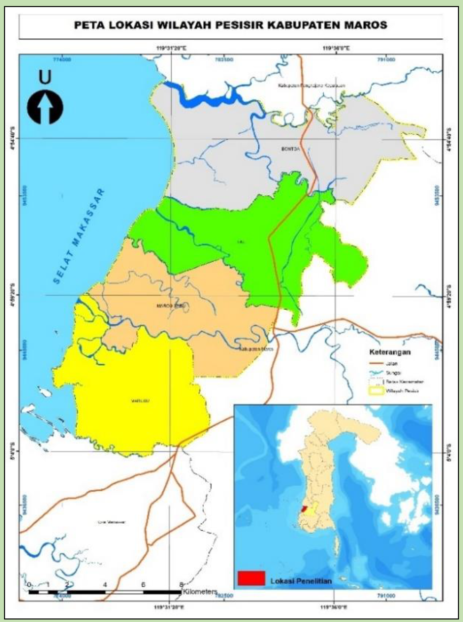
Changes in the area of mangroves in the coastal area of Maros Regency have been degraded from year to year. Various problems that often occur cause a decrease in the distribution and quality of mangrove community health. This happens because there is still pollution and external disturbances which make the quality of the mangroves decrease. Therefore, it is important to know the condition of mangrove distribution to find the latest information and baseline data for area managers. The purpose of this study was to obtain information on the extent and type of mangrove health, as well as identify the types of mangrove damage in the coastal area of Maros Regency in 2021. This research method used (1) supervised classification, to obtain mangrove distribution, (2) analysis of mangrove health using the normalized difference algorithm vegetation Index, (3) map overlay, mangrove distribution map, administrative map, and mangrove health index map, (4) validation of mangrove health data through an assessment of mangrove conditions based on the distribution of observational plots in a proportionate stratified with random sampling. Mangrove areas are found in the coastal areas of Maros Regency and are scattered in Marusu District, Maros Baru District, Lau District, Bontoa District with an area of 131.87 ha, 95.59 ha, 85.37 ha, and 60.01 ha, respectively. Mangrove health is divided into 5 categories, namely excellent, good, normal, bad, and awful with an area of 100.73 ha, 240.43 ha, 1.99 ha, 9.5 ha, and 20.2 ha, respectively. While mangrove damage based on 30 sample points, 6 types of damage were identified, namely changed leaves, damaged shoot leaves and shoots, broken/dead branches, open wounds, resinosis, and broken stems with percentages of 29.91%, 19.63%, 17.76%, 16.82%, 12.15%, and 3.74% respectively.
Abimanyu, B., Safe’i, R., & Hidayat, W. (2019). Aplikasi metode Forest Health Monitoringdalam penilaian kerusakan pohon di Hutan Kota Metro.Jurnal Sylva Lestari,7(3), 289–298.
Ardiansyah, F., Safe’i, R., Hilmanto, R., & Indriyanto. (2018). Analisis kerusakan pohon mangrove menggunakan teknik Forest Health Monitoring (FHM). Prosiding Seminar Nasional Bidang Ilmu-Ilmu Pertanian BKS –PTN Bagian Barat, 763–773.
Arfan, A., Nyompa, S., Maru, R., Nurdin, S., & Juanda, M. F. (2021). Mapping analysis of mangrove areas using Unmanned Aerial Vehicle (UAV) method in Maros District South Sulawesi. Journal of Physics: Conference Series, 2123, 012010.
BIG. (2014). Peraturan Kepala Badan Informasi Geospasial Nomor 3 Tahun 2014 Tentang Pedoman Teknis Pengumpulan dan Pengolahan Data Geospasial Mangrove. Peraturan Kepala Badan Informasi Geospasial Nomor 3 Tahun 2014, 47.
Endeleo. (2020). Indicator : NDVI –Vegetation health & density. Diambil tanggal 18 Oktober 2020 dari https://endeleo.vgt.vito.be/dataproducts.html
Haneda, N. F., & Suheri, M. (2018). Hama mangrove di Kecamatan Batu Ampar, Kabupaten Kubu Raya, Kalimantan Barat. Jurnal Silvikultur Tropika, 9(1), 16–23.
Ibharim, N. A., Mustapha, M. A., Lihan, T., &Mazlan, A. G. (2015). Mapping mangrove changes in the Matang Mangrove Forest using multi temporal satellite imageries. Ocean and Coastal Management, 114, 64–76.
Kawamuna, A., Suprayogi, A., & Wijaya, A. P. (2017). Analisis kesehatan hutan mangrove berdasarkan metode klasifikasi NDVI pada Citra Sentinel-2 (Studi Kasus : Teluk Pangpang Kabupaten Banyuwangi). Jurnal Geodesi Undip, 6, 277–284.
Konom, N. H., Cabuy, R. L., & Wanma, A. O. (2019). Identifikasi kerusakan areal hutan mangrove akibat aktivitas penduduk di daerah Airtiba Kabupaten Kaimana. Jurnal kehutanan papuasia, 5(2), 153–163.
Lukiawan, R., Purwanto, E. H., & Ayundyahrini, M. (2019). Analisis pentingnya standar koreksi geometrik citra satelit resolusi menengah dan kebutuhan manfaat bagi pengguna. Jurnal Standardisasi, 21(1), 45.
Maulida, A. P., & Agustina, E. (2021). Identifikasi kerusakan tanaman mangrove di wilayah pesisir Pantai Aceh Pasca Tsunami. Prosiding Seminar Nasional BiotikIX 2021,9(2), 226–233.
Mayudin, A. (2012). Kondisi ekonomi pasca konversi hutan mangrove menjadi lahan tambak di Kabupaten Pangkajene Kepulauan Provinsi Sulawesi Selatan. Jurnal EKSOS, 8(2), 90–104.
Naufal, N., Asriadi, A., Absar, S., & Al, E. (2022). Avoiding mistakes in drone usage in Participatory mapping: Methodological considerations during the pandemic. Forest and Society, 6(1), 226–242.
Nurdiansah, D., & Dharmawan, I. W. E. (2018). Komunitas mangrove di wilayah pesisir Pulau Tidore dan sekitarnya. OLDI (Oseanologi dan Limnologi di Indonesia), 3(1), 1-9.
Nursaputra, M. (2014). Deteksi tingkat kesehatan hutan sebagai upaya perlindungan dan pelestarian ekosistem penting dalam pengelolaan Daerah Aliran Sungai : (Studi kasus tipe-tipe hutan di DAS Maros Sulawesi Selatan). Tesis. Universitas Gadjah Mada.
Pemerintah Kabupaten Maros. (2011). Kajian lingkungan hidup strategis Kabupaten Maros.
Pemerintah Kabupaten Maros. (2012). Rencana Tata Ruang Wilayah Kabupaten Maros Tahun 2012-2032.
Pemerintah Kabupaten Maros. (2014). Dokumen Rencana Program Investasi Infrastruktur Jangka Menengah (RPI2-JM) Kabupaten Maros. In Penyusunan RPI2-JM Tahun 2014(p. 14).
Pemerintah Kabupaten Maros. (2018). Buku putih sanitasi Kabupaten Maros. In Buku Putih Sanitasi Kabupaten Maros(pp. 1–2).
Pranata, R., Patandean, A. J., Ahmad, Y., & Al., A. (2016). Analisis sebaran dan kerapatan manggrove menggunakan citra landsat 8 di Kabupaten Maros. Jurnal Sains dan Pendidikan Fisika, 12(1), 88–95.
Prasita, V. D. (2015). Determination of shoreline changes from 2002 to 2014 in the mangrove conservation areas of Pamurbaya using GIS. Procedia Earth and Planetary Science, 14, 25–32.
Putri, D. R., Sukmono, A., Sudarsono, B., &Al, E. (2018). Analisis Kombinasi Citra Sentinel-1a Dan Citra Sentinel-2a Untuk Klasifikasi Tutupan Lahan (Studi Kasus: Kabupaten Demak, Jawa Tengah). Jurnal Geodesi Undip, 7(2), 85–96.
Quang, N. H., Quinn, C. H., Stringer, L. C., Carrie, R., Hackney, C. R., Van Hue, L. T., Tan, D. Van, & Thanh Nga, P. T. (2020). Multi-decadal changes in mangrove extent, age and species in the Red River Estuaries of Viet Nam. Remote Sensing, 12(14),2289.
Rahawarin, Y. Y. (2019). Komposisi vegetasi mangrove di muara Sungai Siganoi Sorong Selatan -Papua. Biota : Jurnal Ilmiah Ilmu-Ilmu Hayati, 10(3), 134–140.
Rodriguez, A. (2021). A Comprehensive study of forest health and structure following the west fork fire complex in Southwest Colorado through Normalized Difference Vegetation Index (NDVI) and Normalized Burn Ratio (NBR) item type electronic report; text[The University of Arizona].
Safe’i, R. (2021). Tingkat kesehatan hutan mangrove dalam hubungannya dengan perubahan iklim(Studi kasus mangrove pesisir timur Kabupaten Lampung Timur). Jurnal Hutan Tropis, 9(3), 325-332.
Setiawan, A., Akhbar,A., & Arianingsih, I. (2018). Analsis vegetasi mangrove menggunakan (NDVI) pada ekosistem mangrove di Kecamatan Balinggi Kabupaten Parigi Mountong. Jurnal Forest Sains, 15(2), 82–90.
Short. (1982). The Landsat Tutorial Workbook, New York: The National Aeronautics and Space Administration (NASA). In National Aeronautics and Space Administration Scientific and Technical Information Branch 1982 STANFORD: Vol. 30.
Stehr, A., & Aguayo, M. (2017). Snow cover dynamics in Andean watersheds of Chile (32.0–39.5° S) during the years 2000–2016. Hydrology and Earth System Sciences, 21(10), 5111–5126.
Stringer, C. E., Trettin, C. C., Zarnoch, S. J., & Tang, W. (2015). Carbon stocks of mangroves within the Zambezi River Delta, Mozambique. Forest Ecology and Management, 354, 139–148.
Susilawati, N. G. K., Toknok, B., & Korja, I. N.(2018). Faktor penyebab kerusakan hutan mangrove di Desa Buranga Kecamatan Ampibabo Kabupaten Parigi Moutong. J. Forest Sains, 15(2), 91–99.
Suyadi. (2009). Kondisi hutan mangrove di Teluk Ambon: Prospek dan Tantangan. Berita Biologi, 9(5), 481–490.
Trinanda, T. C. (2017). Pengelolaan wilayah pesisir Indonesia dalam rangka pembangunan berbasis pelestarian lingkungan. Matra Pembaruan(Jurnal Inovasi kebijakan), 1(2), 75–84.
Wali, M., & Ningkeula, E. S. (2019). Tingkat kerusakan batang akibat serangan hama pada tegakan jati. Agrikan: Jurnal Agribisnis Perikanan, 12(2), 272–278.
Winarso. (2018). Metode cepat pemantauan hutan mangrove menggunakan data penginderaan jauh. Seminar nasional geomatika, penggunaan dan pengembangan produk informasi geospasial mendukung daya saing nasional, 901–910.
