
Model Spasial Deforestasi di KPHP Poigar, Provinsi Sulawesi Utara
Downloads
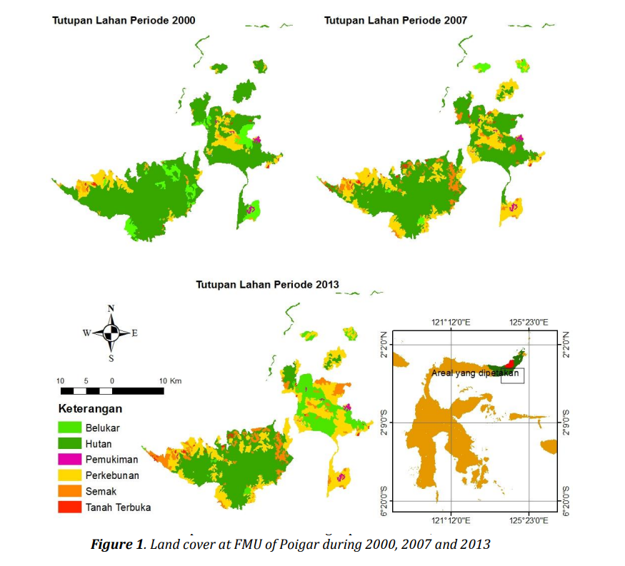
Forest is a part of the ecosystem that provides environmental services. Deforestation may decrease forest function in an ecosystem. This study aims to build a spatial model of deforestation in a forest management unit (FMU) of Poigar. Deforestation analysis carried out by analyze the change of forest cover into non-forest cover with post classification comparison technique. Driving forces of deforestation carried out by spatial modeling using binary logistic regression models (LRM). Result of logistic regression model was used to predict the deforestation in 2013 and compare the prediction result with actual deforestation. The result showed that forest loss from the 2000 to 2013 period amounted 12,668.2 hectares. Deforestation in FMU of Poigar influenced by six factors there are distance from the road, distance from the settlement, distance from the river, population density, elevation and slope. Logistic regression model was built using five explanatory variables that are the distance from the road, distance from the river, population density, elevation and slope. Population density and accessibility is the most influented factor caused deforestation in FMU of Poigar. Prediction of deforestation could predict about 58 % of actual deforestation spatialy, so spatial models of deforestation could be an information to guidance on future management of FMU of Poigar.
Aguayo, M. I., Wiegand, T., Azócar, G. D., Wiegand, K., & Vega, C. E. (2007). Revealing the driving forces of mid-cities urban growth patterns using spatial modeling: A case study of Los Ángeles, Chile. Ecology and Society, 12(1).
Ayalew, L., & Yamagishi, H. (2005). The application of GIS-based logistic regression for landslide susceptibility mapping in the Kakuda-Yahiko Mountains, Central Japan. Geomorphology, 65 (1-2), 15–31.
[BPS] Badan Pusat Statistik. (2010). Penduduk Dan Rumah Tangga Provinsi Sulawesi Utara Hasil Sensus Penduduk Tahun 2010 Menurut Desa/Kelurahan. Manado (ID): BPS.
DeFries, R. S., Rudel, T., Uriarte, M., & Hansen, M. (2010). Deforestation driven by urban population growth and agricultural trade in the twenty-first century. Nature Geoscience, 3(3), 178–181.
[DEPHUT] Departemen Kehutanan. (2007). Rancangan Pembangunan Kesatuan Pengelolaan Hutan (KPH) Model Poigar Di Wilayah Kabupaten Bolaang Mongondow dan Kabupaten Minahasa Selatan Provinsi Sulawesi Utara. Manado (ID): DEPHUT.
Eastman, J. R. (2012). IDRISI Selva Tutorial. Worcester: Clark University.
Eckert, S., Ratsimba, H. R., Rakotondrasoa, L. O., Rajoelison, L. G., & Ehrensperger, A. (2011). Deforestation and forest degradation monitoring and assessment of biomass and carbon stock of lowland rainforest in the Analanjirofo region, Madagascar. Forest Ecology and Management, 262(11), 1996– 2007.
Entwisle, B., Rindfuss, R. R., Walsh, S. J., & Page, P. H. (2008). Population growth and its spatial distribution as factors in the deforestation of Nang Rong, Thailand. Geoforum, 39(2), 879– 897.
[FAO] Food And Agricultural Organization. (2000). Forest resources assessment on definitions of forest and forest change. Rome (IT): FAO.
Geist, H. J., & Lambin, E. F. (2002). Proximate causes and underlying driving forces of tropical deforestation. BioScience, 52(2), 143–150.
Gils, H. A. M. J. v., & Ugon, A. V. L. A. (2006). What drives conversion of tropical forest in Carrasco Province, Bolivia? Ambio, 35(2), 81– 85.
Grecchi, R. C., Gwyn, Q. H. J., Bénié, G. B., Formaggio, A. R., & Fahl, F. C. (2014). Land use and land cover changes in the Brazilian Cerrado: A multidisciplinary approach to assess the impacts of agricultural expansion. Applied Geography, 55, 300–312.
Kartodihardjo, H., Nugroho, B., & Putro, H. R. (2011). Pembangunan Kesatuan Pengelolaan Hutan (KPH) Konsep, Peraturan Perundangan dan Implementasi. Jakarta: Debut Wahana Sinergi.
Kumar, R., Nandy, S., Agarwal, R., & Kushwaha, S. P. S. (2014). Forest cover dynamics analysis and prediction modeling using logistic regression model. Ecological Indicators, 45, 444–455.
Lambin, E. F., & Meyfroidt, P. (2011). Global land use change, economic globalization, and the looming land scarcity. Proc Natl Acad Sci U S A, 108(9), 3465–3472.
Lorena, R. B., & Lambin, E. F. (2009). The spatial dynamics of deforestation and agent use in the Amazon. Applied Geography, 29(2), 171–181.
Mahapatra, K., & Kant, S. (2005). Tropical deforestation: a multinomial logistic model and some country-specific policy prescriptions. Forest Policy and Economics, 7(1), 1–24.
Menard, S. (2002). Applied Logistic Regression Analysis (Quantitative Applications In The Social Sciences). California: Sage Publications.
Müller, R., Müller, D., Schierhorn, F., Gerold, G., & Pacheco, P. (2011). Proximate causes of deforestation in the Bolivian lowlands: an analysis of spatial dynamics. Regional Environmental Change, 12(3), 445–459.
Navratil, P. (2013). Telaah Situasi Penutupan Lahan dan Perubahan Penutupan Lahan di Kabupaten Kapuas Hulu dan Malinau, Indonesia. Jakarta: FORCLIME.
Nawir, A. A., & Rumboko, L. (2008). Sejarah dan kondisi deforestasi dan degradasi lahan. In A. A. Nawir, Murniati, & L. Rumboko (Eds.), Rehabilitasi hutan di Indonesia akan kemanakah arahnya setelah lebih dari tiga dasawarsa? (pp. 13–32). Bogor: CIFOR.
Panta, M., Kim, K., & Joshi, C. (2008). Temporal mapping of deforestation and forest degradation in Nepal: Applications to forest conservation. Forest Ecology and Management, 256(9), 1587–1595.
Prasetyo, L. B., Kartodihardjo, H., Okarda, B., Adiwibowo, S., & Setiawan, Y. (2009). Spatial model approach on deforestation of Java Island, Indonesia. Journal of Integrated Field Science, 6, 37–44.
Restrepo, J. D., Kettner, A. J., & Syvitski, J. P. M. (2015). Recent deforestation causes rapid increase in river sediment load in the Colombian Andes. Anthropocene, 10, 13-28.
Romijn, E., Ainembabazi, J. H., Wijaya, A., Herold, M., Angelsen, A., Verchot, L., & Murdiyarso, D. (2013). Exploring different forest definitions and their impact on developing REDD+ reference emission levels: A case study for Indonesia. Environmental Science & Policy, 33, 246–259.
Turner, B. L., Lambin, E. F., & Reenberg, A. (2007). The emergence of land change science for global environmental change and sustainability. Proceedings of the National Academy of Sciences, 104(52), 20666–20671.
Wyman, M. S., & Stein, T. V. (2010). Modeling social and land-use/land-cover change data to assess drivers of smallholder deforestation in Belize. Applied Geography, 30(3), 329–342.
