The spatial patterns of deforestation in the Ko'mara forest area

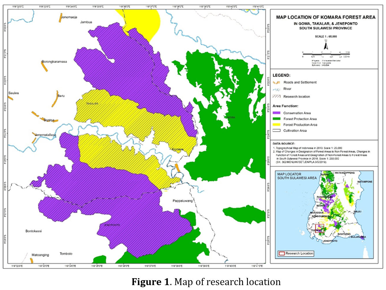
Land-use changes result from changes in the human population, their activities, and social and environmental activities, which occur in a complex and dynamic manner. The change of forested areas to non-forested areas, also known as deforestation, is a land-use change. Deforestation influences land cover by creating a specific distribution pattern (fragmentation). Almost the entire forest has been fragmented into smaller areas, but the pattern of each of these forest areas is uncertain. As a consequence, it would be more challenging to control potential deforestation. Using the spatial metrics of Clumpiness index, Contiguity index, and Patch density, deforestation in one of the forest areas, namely the Ko'mara forest area, was carried out. This research was analyzed using GIS and Fragstat software in raster data format. The analysis results show that the spatial pattern of deforestation in this area has a clumped distribution, with a high level of patch contiguity and a low to medium level of fragmentation. This pattern represents the form of deforestation in the Ko'mara forest area in 2005-2010 and 2010-2015 was classified as Low Deforestation with a deforestation rate of <1%, but was classified as Moderate Deforestation in 2015-2019 because the value obtained was 1.1%.
Altaweel, M.R., Alessa, L.N., Kliskey, A.D., & Bone, C.E. (2010). Monitoring land use: Capturing Change through an information fusion approach. Sustainability, 2(5), 1182–1203. https://doi.org/10.3390/su2051182.
Fajarini, R., Barus, B., & Panuju, D.R. (2015). Dinamika Perubahan Penggunaan Lahan Dan Prediksinya Untuk Tahun 2025 Serta Keterkaitannya Dengan Perencanaan Tata Ruang 2005-2025 Di Kabupaten Bogor. Jurnal Ilmu Tanah Dan Lingkungan, 17(1), 8. https://doi.org/10.29244/jitl.17.1.8-15.
Gunawan, H., Prasetyo, L.B., Mardiastuti, A., & Kartono, A.P. (2010). Fragmentasi Hutan Alam Lahan Kering Di Provinsi Jawa Tengah. Jurnal Penelitian Hutan Dan Konservasi Alam, 7(1), 75–91. https://doi.org/10.20886/jphka.2010.7.1.75-91.
Kastanya, A., & Kastanya, P.Y. (2006). Klasifikasi Penutupan/Penggunaan Lahan Menggunakan Citra Satelit di Kabupaten Halmahera Utara. Agroforestry, 1(2), 1–9.
Kurniawan, I., Barus, B., & Pravitasari, A.E. (2018). Pemodelan Spasial Perubahan Penggunaan Lahan di Taman Nasional Gunung Halimun Salak dan Daerah Penyangganya. Journal of Regional and Rural Development Planning, 1(3), 270. https://doi.org/10.29244/jp2wd.2017.1.3.270-286.
Lillesand, T.M., Kiefer, W.R., & Chipman, J.W. (2005). Remote Sensing and Image Interpretation. In NASPA Journal.
Margono, B.A., Usman, A.B., Budiharto, & Sugardiman, R.A. (2016). Indonesia’s forest resource monitoring. Indonesian Journal of Geography. 48(1), 7. https://doi.org/10.22146/ijg.12496.
McGarigal, K., & Marks, B.J. (1995). FRAGSTATS: spatial pattern analysis program for quantifying landscape structure. (Vol. 351). US Department of Agriculture, Forest Service, Pacific Northwest Research Station.
Morrison, M.L., Marcot, B.G., & Mannan, R.W. (1999). Wildlife-habitat relationships: concepts and applications (781st ed.). NCASI Technical Bulletin.
Munir, A., Atmosoemarto, M., & Arifien, Y. (2017). Perubahan Tutupan Lahan Hutan di Cagar Alam Rawa Danau Menggunakan Citra Landsat dan Sistem Informasi Geografi. Jurnal Nusa Sylva, 17(1), 19-28. https://doi.org/10.31938/jns.v17i1.196.
Nurfatimah. (2020). Klasifikasi Penggunaan Lahan (Issue 1).
Rahmawan, A.D., Pawestri, D.A., Fakhriyah, R.A., Pasha, H.D.S., Ferryandy, M., Sugandi, D., Ridwana, R., & Somantri, L. (2020). Penggunaan Metode Unsupervised (ISO Data) untuk Mengkaji Kerapatan Vegetasi di Kecamatan Pangandaran. Jurnal Pendidikan Geografi Undiksha, 8(1), 01. https://doi.org/10.23887/jjpg.v8i1.22752.
Rijal, S., Barkey, R.A., Nasri, & Nursaputra, M. (2019). Profile, level of vulnerability and spatial pattern of deforestation in Sulawesi Period of 1990 to 2018. Forests, 10(2). https://doi.org/10.3390/f10020191.
Rijal, S., Saleh, M.B., Jaya, I.N.S., & Tiryana, T. (2016). Deforestation Profile of Regency Level in Sumatra. International Journal of Sciences: Basic and Applied Research, 25(2,), 385–402. https://gssrr.org/index.php/JournalOfBasicAndApplied/article/view/5243.
Sahruddin, S., Tjoneng, A., & Numba, S. (2019). Kajian Kawasan Terdegradasi Dan Pola Pemulihan Ekosistemdi Kawasan Suaka Marga Satwa Ko’Mara Kabupaten Takalar. AGROTEK: Jurnal Ilmiah Ilmu Pertanian, 2(2), 1–14. https://doi.org/10.33096/agrotek.v2i2.57.
Septanti, K.S. (2019). Potensi Pemanfaatan Kearifan Lokal Untuk Menahan Konversi Lahan Sawah ke Non Sawah 37(1), 59–75. Forum Penelitian Agro Ekonomi http://dx.doi.org/10.21082/fae.v37n1.2019.59-75.
Setiawan, N. (2007). Penentuan ukuran sampel memakai rumus slovin dan tabel krejcie-morgan: telaah konsep dan aplikasinya. Universitas Padjadjaran. Bandung.
Suhendang, E. (2002). Pengantar Ilmu Kehutanan. Yayasan Penerbit Fakultas Kehutanan IPB.
Tacconi, L. (2012). Illegal logging and the future of the forest. Illegal Logging: Law Enforcement, Livelihoods and the Timber Trade, July, 275–290. https://doi.org/10.4324/9781849771672.
Tampubolon, T., & Yanti, J. (2015). Aplikasi Pemanfaatan Citra Satelit Landsat Di Kota Medan Dan Sekitarnya. Jurnal Fisika Dan Aplikasinya, 16(2), 15–19.

