
Remote Sensing Remote Sensing-Based Soil Erosion Rate Estimation Using the E30 Model and Sentinel-2 Imagery
Downloads
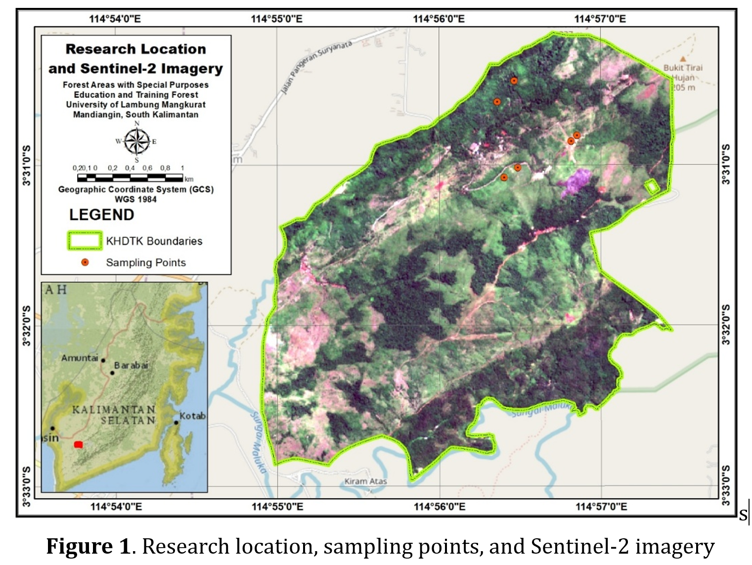
Estimating the rate of soil erosion generally takes time, money, and energy. There are many parameters that must be accommodated, such as the physical properties of the soil, land cover, rainfall, topography, and so on. One alternative method for estimating erosion rates is to use a remote sensing approach. The aim of this research is to estimate the rate of soil erosion in the Special Purpose Forest Area of the University of Lambung Mangkurat (KHDTK ULM) Mandiangin, using the E30 model and Sentinel-2 imagery. The erosion rate are measured directly in the field with a number of sample points. According to the E30 model concept, field erosion samples are only measured on land that has a slope of 300. The topographic data itself is extracted from DEMNAS data. Meanwhile, soil bulk density data was obtained from https://soilgrids.org/, and solum data was taken from https://daac.ornl.gov/. From the Sentinel-2 imagery, Normalized Difference Vegetation Index (NDVI) data was extracted, which is one of the parameters in the E30 model. The estimated results of the erosion rate at KHDTK ULM Mandiangin show that, in general, the highest erosion rate at KHDTK ULM Mandiangin is around 480 tons/ha/year. Additionally, almost 80% of the KHDTK ULM Mandiangin area has a very serious erosion hazard level. Of course, the fastest rate of erosion is located on hill slopes with steep topography. Apart from having steep topography, one of the factors causing the high rate of erosion at KHDTK ULM is the thin soil layer and the lack of dense forest cover. This finding indicates the need to conserve vegetation cover on steep lands.
Hengl, T., Mendes de Jesus, J., Heuvelink, G.B., Ruiperez Gonzalez, M., Kilibarda, M., Blagotić, A., Shangguan, W., Wright, M.N., Geng, X., Bauer-Marschallinger, B., & Guevara, M.A. (2017). SoilGrids250m: Global gridded soil information based on machine learning. PLOS ONE, 12(2), e0169748. https://doi.org/10.1371/journal.pone.0169748.
Honda, K. (1993). Evaluation of vegetation change in the asio copper mine using remote sensing and its application to forest conservation works. D.Eng. dlss. University of Tokyo, Tokyo, Japan.
Honda, K., Samarakoon, L., Ishibashi, A., Mabuchi, Y., & Miyajima, S. (1996). Remote sensing and GIS technologies for denudation estimation in Siwalik watershed of Nepal. Proceeding 17th Asian Conference on Remote Sensing, Colombo, Sri Langka. 4-8 November pp. B21-B26.
Honda, K., Samarakoon, L., & Ishibashi, A. (1998). Erosion control enginnering and geoinformatics; River planform change and sediment yield estimation in a watershed in a watershed of Siwalik, Nepal. In R.B. Singh et al. (Eds.), Space Informatics for sustainable development, Oxford & IBH Publishing CO. Pvt. Ltd., New Delhi, 63-70.
Minister of Forestry of the Republic of Indonesia. (2009). Regulation of the Minister of Forestry of the Republic of Indonesia Number: P. 32/MENHUT-II/2009 concerning Procedures for Preparing Technical Plans for Forest and Watershed Land Rehabilitation (RTkRHL-DAS). Ministry of Forestry of the Republic of Indonesia, Jakarta.
Lathifah, D.A. & Yunianto, T. (2013). Hubungan antara fungsi tutupan vegetasi dan tingkat erosi DAS Secang Kabupaten Kulonprogo. Jurnal Bumi Indonesia, 2(1), 106-114.
Liu, L., Kong, L., Feng, Y.X., Qin, D.D., & Mao, N. (2019). Impacts of tourism development and tourist activities on environment in scenic ecotourism spots. Applied Ecology and Environmental Research, 17(4), 9347-9355. https://doi.org/10.15666/aeer/1704_93479355.
Panagos, P., Ballabio, C., Borrelli, P., Meusburger, K., Klik, A., Rousseva, S., Tadić, M.P., Michaelides, S., Hrabalíková, M., Olsen, P., & Aalto, J. (2015). Rainfall erosivity in europe. The Science of the Total Environment, 511, 801-814. https://doi.org/10.1016/j.scitotenv.2015.01.008.
Pelletier, J.D., Broxton, P.D., Hazenberg, P., Zeng, X., Troch, P.A., Niu, G., Williams, Z.C., Brunke, M.A., & Gochis, D. (2016). Global 1-km gridded thickness of soil, regolith, and sedimentary deposit layers. ORNL DAAC, Oak Ridge, Tennessee, USA. http://dx.doi.org/10.3334/ORNLDAAC/1304.
Rouse, J. W., Jr., Haas Jr., R. H., Schell, J. A., & Deering, D. W. (1974). Monitoring vegetation systems in the Great Plains with ERTS. In Freden, S.C., Mercanti, E.P., Becker, M.A. (Eds.), Third Earth Resources Technology Satellite-1 Symposium, NASA SP-351 I, Washington, DC, 309-317.
Sabri, M.D.Md, Suratman, M.N, Kassim, A.R, Shari, N.H.Z, Khamis, S., & Daim, M.S. (2018). Light intensity and soil compaction as influenced by ecotourism activities in Pahang National Park, Malaysia. National Parks - Management and Conservation. https://doi.org/10.5772/intechopen.74204.
Tobler, W. (1987). Measuring Spatial Resolution. Proceedings, Land Resources Information Systems Conference, Beijing. 1. 12-16. https://www.researchgate.net/publication/291877360_Measuring_spatial_resolution#fullTextFileContent.
Yanti, N.R, Rusnam, R., & Ekaputra, E.G. (2017). Analisis debit pada DAS air dingin menggunakan model SWAT. Jurnal Pertanian Andalas, 21(2), 127-137. https://doi.org/10.25077/jtpa.21.2.127-137.2017.
