
Ecological Disaster in Northern Sumatra: How Extreme Rainfall and Land-Cover Disturbance Triggered Widespread Flash Flooding
Downloads
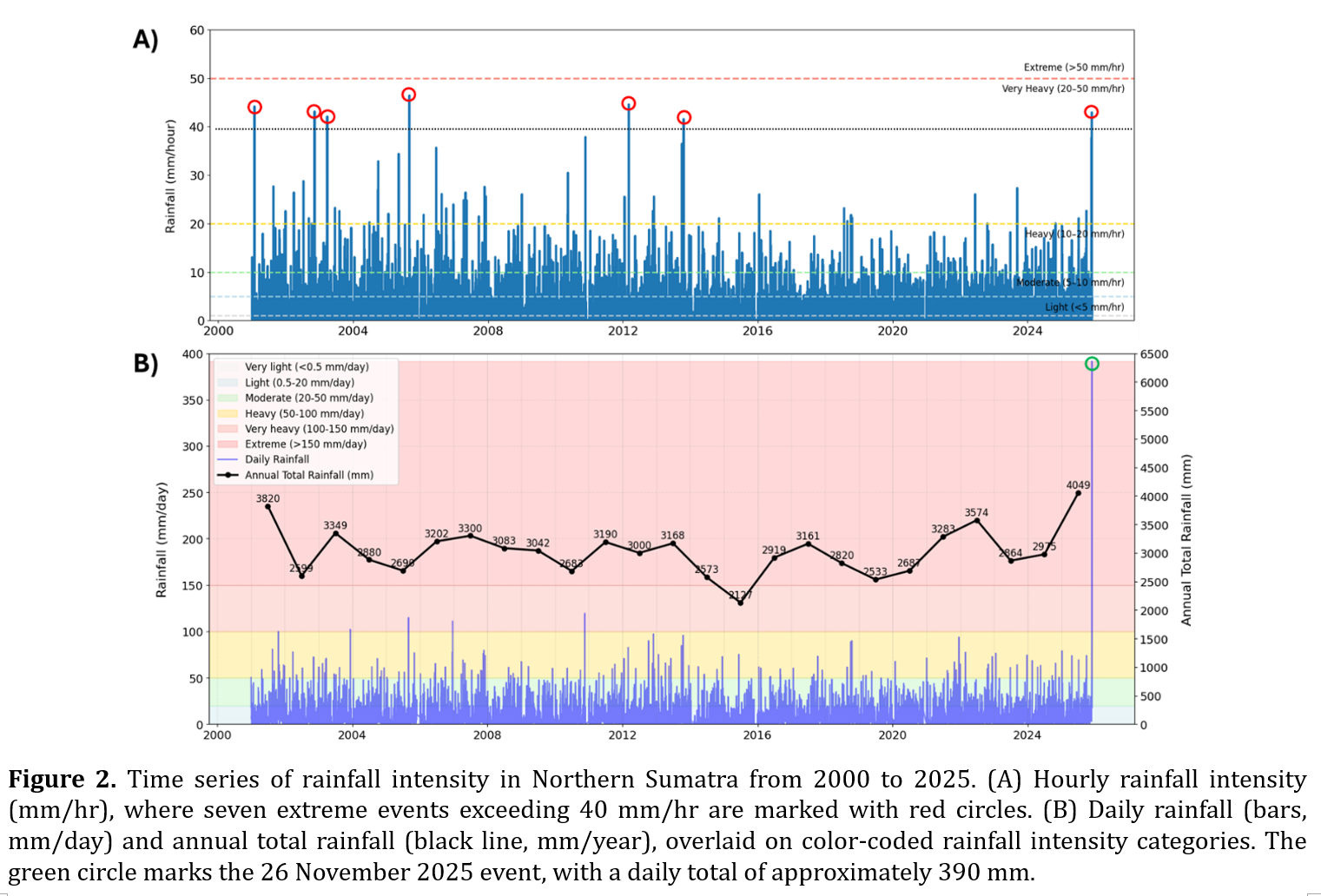
In November 2025, Northern Sumatra experienced one of the most extreme flood disasters in recent history, triggered by a rare combination of sustained high-intensity rainfall and long-term land-cover disturbance. Using satellite-based rainfall estimates, historical rainfall records, and land-cover change analysis, this study examines the spatial and temporal dynamics of the event. The rainfall produced over 950 mm within four days, with daily accumulation exceeding 390 mm and hourly peaks surpassing 40 mm/hr. Statistical analysis using the Generalized Extreme Value (GEV) distribution estimated a return period of approximately 192 years for the daily maximum. Land-cover analysis revealed extensive deforestation between 1990 and 2024, including in designated protection and conservation forest zones. Flood impacts were concentrated in watersheds with high forest loss and recent land disturbance, particularly in Aceh and North Sumatra. This study highlights how compounding hydroclimatic extremes and upstream land degradation can significantly amplify flood risk. The findings underscore the importance of integrating forest conservation and multi-day rainfall indicators into regional flood risk assessments and early warning systems.
Abdulkareem, J.H., Sulaiman, W.N.A., Pradhan, B. & Jamil, N.R. (2018). Relationship between design floods and land use land cover (LULC) changes in a tropical complex catchment. Arabian Journal of Geosciences, 11(14), p.376. https://doi.org/10.1007/s12517-018-3702-4.
AghaKouchak, A., Chiang, F., Huning, L. S., Love, C. A., Mallakpour, I., Mazdiyasni, O., ... & Sadegh, M. (2020). Climate extremes and compound hazards in a warming world. Annual review of earth and planetary sciences, 48(1), 519-548. https://doi.org/10.1146/annurev-earth-071719-055228.
Badan Nasional Penanggulangan Bencana (BNPB). (2025). Bansor Sumatera 2025. Retrieved from https://gis.bnpb.go.id/bansorsumatera2025/.
Basuki, T. M., Nugroho, H. Y. S. H., Indrajaya, Y., Pramono, I. B., Nugroho, N. P., Supangat, A. B., ... & Simarmata, D. P. (2022). Improvement of integrated watershed management in Indonesia for mitigation and adaptation to climate change: A review. Sustainability, 14(16), 9997. https://doi.org/10.3390/su14169997.
Bathurst, J. C., Bovolo, C. I., & Cisneros, F. (2010). Modelling the effect of forest cover on shallow landslides at the river basin scale. Ecological Engineering, 36(3), 317-327. https://doi.org/10.1016/j.ecoleng.2009.05.001.
Cao, Q., Liu, Y., Georgescu, M., & Wu, J. (2020). Impacts of landscape changes on local and regional climate: A systematic review. Landscape Ecology, 35(6), 1269-1290. https://doi.org/10.1007/s10980-020-01015-7.
Chen, L., Li, Y., & Cheng, Z. (2010). An overview of research and forecasting on rainfall associated with landfalling tropical cyclones. Advances in Atmospheric Sciences, 27(5), 967-976. https://doi.org/10.1007/s00376-010-8171-y.
Costa Alves, R. M., Neves Lousada, S. A., Cabezas, J., & Naranjo Gómez, J. M. (2023). Urban Flooding Risk in Machico and Planning Its Territory as a Form of Prevention. In S. Lousada (Ed.), Geoinformatics in Support of Urban Politics and the Development of Civil Engineering (pp. 50-76). IGI Global Scientific Publishing. https://doi.org/10.4018/978-1-6684-6449-6.ch003.
Cutter, S. L., Boruff, B. J., & Shirley, W. L. (2003). Social vulnerability to environmental hazards. Social Science Quarterly, 84(2), 242–261. https://doi.org/10.1111/1540-6237.8402002.
Daly, C., Conklin, D. R., & Unsworth, M. H. (2009). Local atmospheric decoupling in complex topography alters climate change impacts. International Journal of Climatology. 30 (12): 1857-1864. https://doi.org/10.1002/joc.2007.
Dimri, A. P. (2009). Impact of subgrid scale scheme on topography and landuse for better regional scale simulation of meteorological variables over the western Himalayas. Climate dynamics, 32(4), 565-574. https://doi.org/10.1007/s00382-008-0453-z.
Dolidon, N., Hofer, T., Jansky, L., & Sidle, R. (2009). Watershed and forest management for landslide risk reduction. In Landslides–disaster risk reduction (pp. 633-649). Berlin, Heidelberg: Springer Berlin Heidelberg. https://doi.org/10.1007/978-3-540-69970-5_33.
Golar, G., Muis, H., Isrun, I., Simorangkir, W. S., Fadhliah, F., Ali, M. N., & Basir-Cyio, M. (2024). Deforestation as a catalyst for natural disaster and community suffering: A cycle in the socioecological system. Folia Forestalia Polonica. Series A. Forestry, 66(2). https://doi.org/10.2478/ffp-2024-0007.
Gori, A., Lin, N. & Xi, D. (2020). Tropical cyclone compound flood hazard assessment: From investigating drivers to quantifying extreme water levels. Earth's Future, 8(12), p.e2020EF001660. https://doi.org/10.1029/2020EF001660.
Goyal, S., Mohapatra, M., Dube, S. K., Kumari, P., & De, I. (2016). Mesoscale convective systems in association with tropical cyclones over Bay of Bengal. Natural Hazards, 82(2), 963-979. https://doi.org/10.1007/s11069-016-2229-9.
Houze Jr, R. A. (2012). Orographic effects on precipitating clouds. Reviews of Geophysics, 50(1). https://doi.org/10.1029/2011RG000365.
Huang, C. Y., Chou, C. W., Chen, S. H., & Xie, J. H. (2020). Topographic rainfall of tropical cyclones past a mountain range as categorized by idealized simulations. Weather and Forecasting, 35(1), 25-49. https://doi.org/10.1175/WAF-D-19-0120.1.
Jothityangkoon, C., Hirunteeyakul, C., Boonrawd, K., & Sivapalan, M. (2013). Assessing the impact of climate and land use changes on extreme floods in a large tropical catchment. Journal of Hydrology, 490, 88-105. https://doi.org/10.1016/j.jhydrol.2013.03.036.
Mantero, G., Morresi, D., Marzano, R., Motta, R., Mladenoff, D. J., & Garbarino, M. (2020). The influence of land abandonment on forest disturbance regimes: a global review. Landscape Ecology, 35(12), 2723-2744. https://doi.org/10.1007/s10980-020-01147-w.
Nepal, S., Flügel, W. A., & Shrestha, A. B. (2014). Upstream-downstream linkages of hydrological processes in the Himalayan region. Ecological Processes, 3(1), 19. https://doi.org/10.1186/s13717-014-0019-4.
Silpamol, D. S., Kottayil, A., John, V. O., & Xavier, P. (2025). Characteristics of mesoscale convective systems during monsoon extreme rainfall events: case studies from the southwest coast of India. Natural Hazards, 121, 16897–16913 . https://doi.org/10.1007/s11069-025-07455-1.
United Nations Office for Disaster Risk Reduction (UNDRR). (2019). Global assessment report on disaster risk reduction 2019. UNDRR. eISBN: 978-92-1-004180-5
Van Vliet, M. T., Thorslund, J., Strokal, M., Hofstra, N., Flörke, M., Ehalt Macedo, H., ... & Mosley, L. M. (2023). Global river water quality under climate change and hydroclimatic extremes. Nature Reviews Earth & Environment, 4(10), 687-702. https://doi.org/10.1038/s43017-023-00472-3.
Widodo, T. N., Zubair, H., & Padjung, R. (2021). Land use change study and the increased risk of floods disaster in Jeneberang watershed at Gowa Regency, South Sulawesi, Indonesia. In IOP Conference Series: Earth and Environmental Science (Vol. 824, No. 1, p. 012045). IOP Publishing. https://doi.org/10.1088/1755-1315/824/1/012045.
Wisner, B., Blaikie, P., Cannon, T., & Davis, I. (2004). At risk: Natural hazards, people’s vulnerability and disasters (2nd ed.). Routledge. https://doi.org/10.4324/9780203428764.
Zscheischler, J., Westra, S., Van Den Hurk, B. J., Seneviratne, S. I., Ward, P. J., Pitman, A., ... & Zhang, X. (2018). Future climate risk from compound events. Nature Climate Cchange, 8(6), 469-477. https://doi.org/10.1038/s41558-018-0156-3.
