Wave Measurement Accuracy In Front Of Floating Breakwater Model
Main Article Content
Abstract
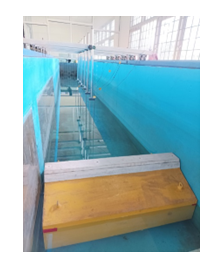
Sea waves are the movement of sea water on the surface with an up or down motion that is shaped the same as a sinusoidal line, which can arise due to the generating force on the sea surface with various types of sea wave generation by the wind, the attractive force between the earth, the moon and the sun, earthquakes and finally by the movement of the ship. Regular waves were tested in a wave flume 25 m long, 1 m wide and 1.2 m deep equipped with a flap type wave generator. The wave absorber at the other end is built from a mound of rock. Eight wave measuring points (HR Wallingford 8 channels) are co-located with the wavelength. Wave probes 1-5 are set at 0.1L while 5-8 are set at 0.2L. The wave generator then produces fluctuations in the water level that increase until it reaches the desired wave height. After several incoming waves, the reflected waves then lower the fluctuations in the water level until they reach a stable wave condition (which has the same shape and peak height) which indicates that the resulting waves are linear waves. The R2 method is used to evaluate the accuracy of wave measurement, that the two-point method with a wave measuring distance of 0.2L is the best method for measuring wave height. The two methods are compared with the general method to obtain the appropriate one for each case. The generated waves tend to be nonlinear with increasing wave height. The accuracy is reduced due to the nonlinearity of the resulting waves. Wave generator performance can be improved by reducing wave reflection. There is an influence of the distance of the wave meter on the accuracy of the wave height measurement. Good accuracy can be achieved at a wave probe distance of 0.2L for the two-point and three-point methods.
Downloads
Article Details

This work is licensed under a Creative Commons Attribution 4.0 International License.
Allow anyone to modify, improve, and make derivative works, even for commercial purposes, as long as they credit to you for the original work.
References
Ayunarita S., 2017, Studi Pola Arus, Pasang Surut Dan Gelombang di Perairan Pantai Pelawan DesaPangke Kecamatan Meral Kabupaten Karimun Provinsi Kepulauan Riau, Fakultas Perikanan danKelautan. Universitas Riau, Pekanbaru.
S. Rahman and T. Pairunan, “Wave Force on Breakwater Structure in North Kalimantan”, mp, vol. 1, no. 1, pp. 26-33, Feb. 2022.
Ghozali, I., 2016, Aplikasi Analisis Multivariete Dengan Program IBM SPSS 23 (Edisi 8), BadanPenerbit Universitas Diponegoro, Semarang
Kurniawan, R., 2012, Karakteristik Gelombang Laut dan Daerah Rawan Gelombang Tinggi diPerairan Indonesia (Tesis), Universitas Indonesia, Depok
Sutedjo, A., Pradana S., 2018, Perairan Laut, Kementerian Pendidikan dan Kebudayaan Riset,Teknologi dan Pendidikan Tinggi, RISTEKDIKTI, Jakarta
Triatmodjo, B., 2012, Perencanaan Bangunan Pantai, Beta Offset, Yogyakarta.
Wakkary, AC., Ihsan, MJ., Dundu, A.K.T., 2017, Studi Karakteristik Gelombang Pada Daerah PantaiDesa Kalinaung KAB. Minahasa Utara, Jurnal Sipil Statik, Vol. 5(3): 167-174 ISSN: 2337-6732,Jakarta
Yuan, Z., BS Chauhan dan H.-C. Lim, 2013, Mekanika Terapan dan Material, Studi penyerap gelombang di berbagai jarak ditempatkan dalam gelombang merambat sinusoidal, 302, 326 – 331

