
ANALYSIS OF MAXIMUM WAVE HEIGHT DATASET FOR LICENSING LOW-RISK MARINE SPACE USE IN SULAWESI ISLAND WATERS
Article Sidebar
Main Article Content
Abstract
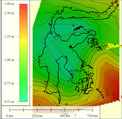
With the rule of Indonesian Law No. 3 of 2023 concerning the Stipulation of Perpu 2 of 2022 concerning Job Creation and its derivatives/OMNIBUSLAW which have an impact on the management of licensing for the utilization of marine space, wave height datasets which are data that must be attached to the proposal for submission of a Marine Space Utilization Conformity Confirmation Approval (PKKPRL) are very important. However, most of the existing data requires further analysis and will make it difficult for small-scale marine space utilization businesses with activities that have a relatively low level of risk to the marine and coastal environment. Therefore, a dataset of wave height data that has been analyzed from the available data is needed so that it will be easily used by small-scale marine space utilization businesses in submitting PKKPRL proposals. This study presents an analysis of maximum wave height in the period 1999-2023 in Sulawesi seas obtained from monthly significant wave height data from altimetry satellites that have been reanalyzed by ECMWF (European Centre for Medium-Range Weather Forecasts) and presented in the form of digital maps. This dataset is expected to make it easier for small businesses to utilize it in the process of applying for marine space utilization permits.
Downloads
Article Details
References
Indonesia Pemerintah Pusat, "Undang Undang No. 6 Tahun 2023 tentang Penetapan Peraturan Pemerintah Pengganti Undang-Undang No. 2 Tahun 2022 tentang Cipta Kerja,Jakarta, 2023
Kementerian Kelautan dan Perikanan RI, "Peraturan menteri Kelautan dan Perikanan No. 28 Tahun 2021 tentang Penataan Ruang Laut”, Jakarta, 2023
Bambang Triatmodjo, "Teknik Pantai," Beta Offset, Yogyakarta , 1999.
Coastal Engineering Research Centre, “Shore Protection Manual 1984”, department of the Army US ARMY Corps Engineers Waterway Experiments Station, Viskburg Mississippi, Washington DC, 1984
N. Nadya and A. Salim, “Pengaruh Sea Level Rise Di Wilayah Perkotaan Indonesia”, Sensistek, vol. 6, no. 1, pp. 52-55, May 2023.
C. Chaidir And N. D. Tuharea, “Comparative Analysis Of Tidal Data Using Correlation Coefficient And Rmse Methods Between Ioc Sealevelmonitoring Data And Naotid Program Data”, Sensistek, Vol. 5, No. 2, Pp. 84-89, Dec. 2022.
A. W. Mustadir, “Performance Of Variation Of Beach-Type Wave Absorers Porous Ramps And Parabolas In Wave Tank Marine Technology Laboratory”, Sensistek, Vol. 5, No. 2, Pp. 162-167, Nov. 2022.