Study of the Shipping Flow of the Pattumbukang Ferry Port, Selayar Islands Regency South Sulawesi
Article Sidebar
Main Article Content
Abstract
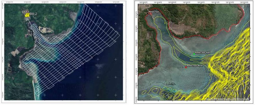
The Pattumbukang Ferry Port is one of the ferry ports in the Selayar Archipelago, South Sulawesi. This port is located in a small bay which results in several problems related to sedimentation and narrowing of the water area. To prevent silting due to existing sedimentation, it is necessary to carry out shipping channel planning and dredging the seabed to obtain the required depth. The purpose of this study was to determine the hydro-oceanographic conditions at the Pattumbukang Ferry Port which was then used as a source of information regarding the depth and planning of water levels for material for evaluating shipping lane planning and estimating dredging volumes. Data collection in this study was carried out directly at the location for 15 days. Observations were made to obtain data in the form of: bathymetry data, tides, and soil sediment samples. The existing data is then processed and analyzed in shipping channel planning using assistance software, like :ArcGIS, Civilian 3D, Mapsource and software other supporters. Based on the results of the survey and processed data that has been carried out in this study, it can be concluded that: The existing condition of the shipping channel at the Pattumbukang Ferry Port does not meet the criteria based on the largest ship size, namely 1000 GT. Therefore, a one-way route planning is carried out with two alternative choices of channels where each alternative has its own advantages and disadvantages and with an ideal depth of 5.528≈ 6 m
Downloads
Article Details

This work is licensed under a Creative Commons Attribution 4.0 International License.
Accepted 2023-06-27
Published 2023-06-27
References
Bruun, P. (1981).Port Engineering Volume 1. Gulf Publishing Co. USA.
Noble, Yati. 2020. Coastal Engineering. Bandung: Itenas.
Mulyono, Try. 2019. Harbor 1. Jakarta: UNJ Press.
Mutiara, Indra., Hamzah Muhiddin, Amir. 2015. Tidal Observations for Determining the Datum of Height at the Beach of Parak Village, Bonto Matene District, Selayar Regency, South Sulawesi Province. Journal : SPERMONDE (2016) 2(2) Pg.44-46
Poerbandono, Djunarsjah, Eka. 2005. Hydrographic Survey. Bandung : PT. Aditama Refika.
Thoresen, Carl A. 2014. Port Designer’s Handbook Third Edition : Institute Of Civil Engineering.