
Utilization of Tsunami Modeling in Determining Temporary Evacuation Spots on the Labuan Coast
Article Sidebar
Main Article Content
Abstract
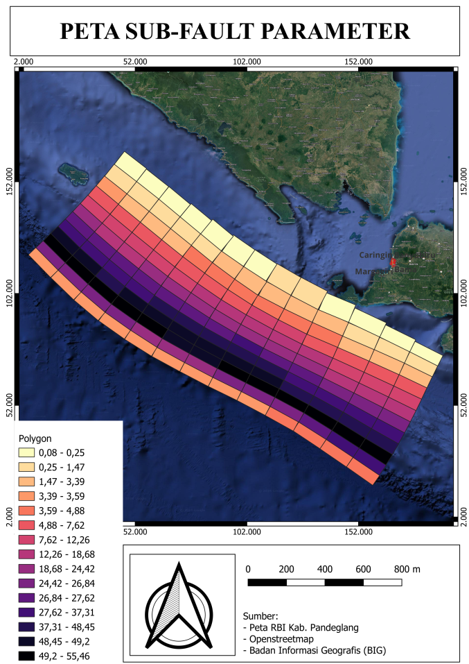
Indonesia is one of the countries with more water surface than land and, in addition, its territory is located between three plates: the Indo-Australian, the Eurasian and the Pacific. This makes Indonesia a country with high volcanic and seismic activity. The abundant news related to mega-earthquakes has made many Indonesians wary of these phenomena. The Sunda Strait is one of the places where megathrustings are expected to occur, and Banten, being a province located in the ocean of the Sunda Strait, makes the level of vigilance high. The modeling process related to tsunami is a representation that can visualize if a large earthquake occurs and causes a tsunami, especially in the coastal area of Labuan subdistrict. The objective of this research is to determine the temporary evacuation spots in tsunami affected areas using tsunami modeling performed with COMCOT (Cornell Multi-grid Coupled Tsunami Grid). The modeling results obtained a wave height to the shoreline of 15 meters with a period to the shoreline of 60 minutes. Twelve temporary evacuation spots (TES) were determined in this study, 9 of the 12 spots become safe TES because the point has a higher ground level and is out of the inundation range.
Downloads
Article Details

This work is licensed under a Creative Commons Attribution 4.0 International License.
Allow anyone to modify, improve, and make derivative works, even for commercial purposes, as long as they credit to you for the original work.
Accepted 2025-03-30
Published 2025-03-31
References
[1]Aldison, J. (2021). Kajian Jalur Evakuasi Serta Tempat Evakuasi Bencana Tsunami Terhadap Hasil Partisipatif Masyarakat di Pesisir Kecamatan Limau Kabupaten Tanggamus.
[2]Amalia, S. (2022). Analisis Dampak Korupsi Pada Masyarakat (Studi Kasus Korupsi Pembangunan Shelter Tsunami di Kecamatan Labuan Kabupaten Pandeglang). Epistemik: Indonesian Journal of Social and Political Science, 3(1), 54-76.
[3]Anwar, S., Winarna, A., & Suharto, P. (2020). Strategi pemberdayaan wilayah pesisir dalam menghadapi bencana tsunami serta implikasinya terhadap ketahanan wilayah (Studi di desa Bulakan, kecamatan Cinangka, kabupaten Serang, Banten). Jurnal Ketahanan Nasional, 26(1), 108-131.
[4]Arianto, M. F. (2020). Potensi wilayah pesisir di negara Indonesia. Jurnal Geografi, 10(1), 204-215.
[5]Ayunda, G., Ismanto, A., Hariyadi, H., Sugianto, D. N., & Helmi, M. (2020). Analisis penjalaran run-up gelombang tsunami menggunakan pemodelan numerik 2D di Pesisir Kota Bengkulu. Indonesian Journal of Oceanography, 2(3), 253-260.
[6]Azhari, D. R., Lestari, D. A., & Arifin, W. A. (2022). Pemodelan Spasial Genangan Banjir Rob, Studi Kasus: Pesisir Utara Banten (Kecamatan Kasemen). Jurnal Georafflesia: Artikel Ilmiah Pendidikan Geografi, 7(2), 173-181.
[7]Fedryansyah, M., Pancasilawan, R., & Ishartono, I. (2018). Penganggulangan Bencana Di Masyarakat Desa Studi Di Desa Cipacing, Desa Cileles, Dan Desa Cikeruh Kecamatan Jatinangor Kabupaten Sumedang. Share: Social Work Journal, 8(1), 11-16.
[8]Amaanah A, Haryani D.D, Fauziah D. (2024). Studi Kelayakan Dan Rekomendasi Penempatan
[9]Jalinus, N., & Risfendra, R. (2020). Analisis kemampuan pedagogi guru smk yang sedang mengambil pendidikan profesi guru dengan metode deskriptif kuantitatif dan metode kualitatif. INVOTEK: Jurnal Inovasi Vokasional Dan Teknologi, 20(1), 37-44.
[10]Lestari, D. A., Anzani, L., Zamil, A. S., Prasetyo, A., Simbolon, E. F., & Apriansyah, M. R. (2020). Pengaruh Gunung Laut Anak Krakatau terhadap pertumbuhan rumput laut di Selat Sunda. Jurnal Kemaritiman: Indonesian Journal of Maritime, 1(2), 75-88.
[11]Mandey, T. C., Ismanto, A., Sugianto, D. N., Purwanto, P., Widiaratih, R., & Harsono, G. (2021). The Modeling of Tsunami Wave Run-Up and Vulnerability Zone Analysis In Cipatujah, Tasikmalaya District. Indonesian Journal of Oceanography, 3(4), 400-408.
[12]Noviansah, K. (2024). PENENTUAN JALUR EVAKUASI DAN TEMPAT PENGUNGSIAN SEMENTARA TERHADAP POTENSI BENCANA TSUNAMI DI KECAMATAN BAYAH, KABUPATEN LEBAK (Doctoral dissertation, Universitas Pendidikan Indonesia).
[13]Pandapotan, I. (2019). Strategi Pemerintah Indonesia Mempertahankan Kedaulatan di Wilayah Terdepan (Studi pada Wilayah Kepulauan Natuna Tahun 2009-2017) (Doctoral dissertation, Universitas Sumatera Utara).
[14]Pusat Gempabumi dan Tsunami Kedeputian Bidang Geofisika, 2019. Katalog Tsunami Indonesia. Penerbit BMKG Jakarta.
[15]Rahmadani, F. S. (2022). Analisis Jalur Evakuasi Tsunami Di Kota Palu (Doctoral dissertation, Universitas Hasanuddin).
[16]Ramadhanu, A. P., & Nur, H. PENENTUAN LOKASI LAHAN TEMPAT EVAKUASI SEMENTARA BERUPA HORIZONTAL BENCANA TSUNAMI DI KECAMATAN TANJUNG MUTIARA, KABUPATEN AGAM. Abstract of Undergraduate Research, Faculty of Civil and Planning Engineering, Bung Hatta University, 2(3), 27-28.
[17]Rasyif, T. M., Kato, S., Syamsidik, & Okabe, T. (2019). Numerical simulation of morphological changes due to the 2004 tsunami wave around banda aceh, indonesia. Geosciences, 9(3), 125.
[18]Sadisun, I. A. (2004). Manajemen bencana: Strategi hidup di wilayah berpotensi bencana. Keynote Speaker, 1-3.
[19]Solihuddin, T., Salim, H. L., Husrin, S., Daulat, A., & Purbani, D. (2020). Dampak tsunami selat sunda di Provinsi Banten dan upaya mitigasinya. Jurnal Segara, 16(1), 15-28.
[20]Sriyanto, S. P. D., Nurfitriani, N., Zulkifli, M., & Wibowo, S. N. E. (2019). Pemodelan Inundasi dan Waktu Tiba Tsunami di Kota Bitung, Sulawesi Utara Berdasarkan Skenario Gempabumi Laut Maluku. GEOMATIKA, 25(1), 47-54.
[21]Sulistyadi, Y., Eddyono, F., & Entas, D. (2019). Pariwisata berkelanjutan dalam perspektif pariwisata budaya di Taman Hutan Raya Banten. Uwais Inspirasi Indonesia.
[22]Syafitri, A. N. (2020). ANALISIS CENTROID MOMENT TENSOR (CMT) GEMPA BUMI DI SELAT SUNDA PADA 22 DESEMBER 2018 SEBELUM TSUNAMI BANTEN. Jurnal Inovasi Fisika Indonesia (IFI), 9(2), 178-183.
[23]Ulfani, A., Helmi, M., & Kunarso, K. (2024). Studi Area Genangan Banjir Pasang dan Dampaknya Terhadap Penggunaan Lahan Pesisir Berdasarkan Pemodelan Geospasial di Kecamatan Genuk, Kota Semarang, Jawa Tengah. Indonesian Journal of Oceanography, 6(2), 188-196.
[24]ARIFIN, W. A., LA ODE ALAM, M. I. N. S. A. R. I. S., ROSALIA, A. A., AHMAD SATIBI, M. R., DZIKRILLAH, A., APRIANSYAH, M. R., & EFENDI, E. (2023). BIBLIOMETRIC COMPUTATIONAL MAPPING ANALYSIS OF PUBLICATIONS OF MARINE INFORMATION SYSTEM USING VOSVIEWER. Journal of Engineering Science and Technology, 18(6), 3018-3028.
[25]Lokasi Shelter Untuk Evakuasi Bencana Tsunami Sebagai Upaya Mitigasi Berkelanjutan di Kabupaten Pandeglang. MAPID.