
The Role Of Coastal Forest In Tsunami Reduction Using Comcot
Article Sidebar
Main Article Content
Abstract
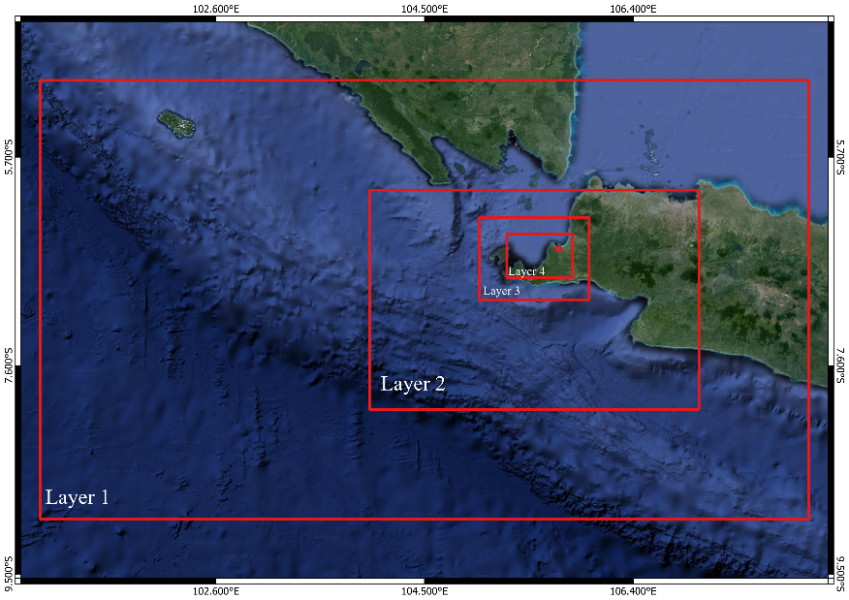
Panimbang sub-district is one of the areas affected by the tsunami in 2018, located directly opposite the Krakatau Volcano and close to the Sunda Strait subduction zone (megathrust), making it an area with a high threat of tsunami levels. This study aims to determine the impact of coastal forests in reducing tsunamis using COMCOT modeling as one of the mitigation efforts. The tsunami generator used uses the worst scenario earthquake that can occur in the Sunda Strait subduction zone area. The results show that the coastal forest in Panimbang sub-district with a width of 380 m can reduce the tsunami velocity by 50% compared to the coastal forest with a width of 30 m. In addition, the manning coefficient (n) value also has an influence in reducing the inundation area, inundation level height, and tsunami velocity.
Downloads
Article Details

This work is licensed under a Creative Commons Attribution 4.0 International License.
Allow anyone to modify, improve, and make derivative works, even for commercial purposes, as long as they credit to you for the original work.
Accepted 2025-03-30
Published 2025-03-31
References
[1] S. Widiyantoro et al., “Implications for megathrust earthquakes and tsunamis from seismic gaps south of Java Indonesia,” Sci Rep, vol. 10, no. 1, Dec. 2020, doi: 10.1038/s41598-020-72142-z.
[2] T. Solihuddin, H. L. Salim, S. Husrin, A. Daulat, and D. Purbani, “Dampak Tsunami Selat Sunda Desember 2018 Di Provinsi Banten dan Upaya Mitigasinya,” Jurnal Segara, vol. 16, no. 1, Jun. 2020, doi: 10.15578/segara.v16i1.8611.
[3] J. P. Wilayah, D. Kota, T. Wijanarko, L. Tondobala, F. Ontang, and P. Siregar, “MITIGASI BENCANA TSUNAMI DI WILAYAH PESISIR KABUPATEN BOLAANG MONGONDOW TIMUR TSUNAMI DISASTER MITIGATION IN THE COASTAL AREA OF EAST BOLAANG MONGONDOW REGENCY,” Jurnal Spasial, vol. 9, no. 1, p. 2022.
[4] K. Harada and F. Imamura, “Effects of Coastal Forest on Tsunami Hazard Mitigation — A Preliminary Investigation,” Advances in Natural and Technological Hazards Research, vol. 23, pp. 279–292, 2005, doi: 10.1007/1-4020-3331-1_17.
[5] Susanto, D., Faida, L. R. W., & Sunarto, S. (2019). Pemodelan Efektivitas Hutan Pantai di Cagar Alam Pananjung Pangandaran Sebagai Buffer Tsunami. Jurnal Ilmu Kehutanan, 13(1), 4-14.
[6] Tursina and Syamsidik, “Numerical simulations of land cover roughness influence on tsunami inundation in Ulee Lheue Bay, Aceh-Indonesia,” in IOP Conference Series: Earth and Environmental Science, Institute of Physics Publishing, Mar. 2017. doi: 10.1088/1755-1315/56/1/012009.
[7] Fachrurrazi, Syamsidik, M. Al’Ala, and W. Mahardi, “Numerical simulations of tsunami waves impacts on Ulee Lheue Harbour in Banda Aceh-Indonesia,” in IOP Conference Series: Earth and Environmental Science, Institute of Physics Publishing, Mar. 2017. doi: 10.1088/1755-1315/56/1/012015.
[8] A. Fatimah, R. Djamaluddin, S. Darwisito, J. M. Mamuaja, A. S. Wantasen, and J. N. W. Schaduw, “Pemodelan Numerik Tsunami untuk Mengestimasi Waktu Tiba dan Ketinggian Maksimum Gelombang Tsunami di Teluk Amurang,” Euler : Jurnal Ilmiah Matematika, Sains dan Teknologi, vol. 11, no. 1, pp. 8–15, May 2023, doi: 10.34312/euler.v11i1.19463.
[9]. -F Woo and S.-B. Cho, “USER MANUAL FOR COMCOT VERSION 1.7 (FIRST DRAFT),” 1998.
[10] Rasyif TM, Kato S, Syamsidik, and Okabe T. Numerical Simulation of MorphologicalChanges Due to the 2004 Tsunami Wave Around Banda Aceh, Indonesia. Geosciences(Switzerland). 2019; 9(3): 125. DOI: https://doi.org/10.3390/geosciences9030125.
[11] G. Cárdenas and P. A. Catalán, “Accelerating Tsunami Modeling for Evacuation Studies through Modification of the Manning Roughness Values,” GeoHazards, vol. 3, no. 4, pp. 492–507, Dec. 2022, doi: 10.3390/geohazards3040025.
[12] L. Li, Q. Qiu, and Z. Huang, “Numerical modeling of the morphological change in Lhok Nga, west Banda Aceh, during the 2004 Indian Ocean tsunami: Understanding tsunami deposits using a forward modeling method,” Natural Hazards, vol. 64, no. 2, pp. 1549–1574, Oct. 2012, doi: 10.1007/s11069-012-0325-z.
[13] D. A. Lestari, N. S. Fitriasari, T. E. Ahmad, A. Rais, and D. R. Azhari, “Spatial Analysis on Tsunami Predictions in Pandeglang Regency,” Forum Geografi, vol. 35, no. 1, Jan. 2021, doi: 10.23917/forgeo.v35i1.12367.
[14] G. Kaiser, L. Scheele, A. Kortenhaus, F. Løvholt, H. Römer, and S. Leschka, “The influence of land cover roughness on the results of high resolution tsunami inundation modeling,” Natural Hazards and Earth System Science, vol. 11, no. 9, pp. 2521–2540, 2011, doi: 10.5194/nhess-11-2521-2011.
[15] B. Shigenobu Tanaka Dinar Catur Istiyanto Daisuke Kuribayashi, “Planning and Design of Tsunami-mitigative Coastal Vegetation Belts.”