Application Of Remote Sensing Technology And Geographic Information Systems For Tsunami Vulnerability Analysis In Mamuju District
Main Article Content
Abstract
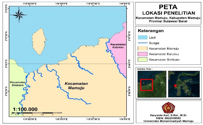
This research aims to analyze the vulnerability to tsunami disasters in Mamuju District, West Sulawesi, using remote sensing technology and Geographic Information Systems (GIS). Mamuju District is at high risk of tsunamis due to its coastal location and its position between active tectonic plates. The analysis utilizes five main parameters: elevation, slope gradient, distance from rivers, distance from the coastline, and land cover. The GIS overlay analysis method is applied to map tsunami hazard zones, combining weighting and scoring for each parameter. The results indicate that 3% of the area has very high vulnerability, 7% of the area has high vulnerability, while 82% of the area has low to very low vulnerability. Areas with very high vulnerability include the coastal zone directly adjacent to the shoreline and residential areas. This study is expected to serve as a reference for local governments and disaster management agencies in efforts to mitigate and plan safer spatial arrangements against tsunami threats. Mitigation strategy recommendations include the construction of evacuation routes, safe shelters, and the regular enhancement of disaster education and simulations for the community. Furthermore, this research encourages the use of mountainous areas as primary evacuation zones and collaboration with research institutions for the development of more innovative mitigation technologies.
Downloads
Article Details

This work is licensed under a Creative Commons Attribution 4.0 International License.
Allow anyone to modify, improve, and make derivative works, even for commercial purposes, as long as they credit to you for the original work.
References
Adilang, D.C., Tungka, A.E. and Warouw, F. 2022. Pemetaan Jalur Evakuasi Tsunami Dengan Metode Network Analyst Berbasis Sig Di Kota Manado. Jurnal Spasial 9(1), pp. 52–61. Available at: https://ejournal.unsrat.ac.id/v3/index.php/spasial/article/view/41902.
Agussaini, H., Sirojuzilam, Rujiman and Purwoko, A. 2022. A New Approach of the Tsunami Mitigation Strategies for the City of Banda Aceh, Indonesia. Indonesian Journal of Geography 54(1), pp. 62–69. doi: 10.22146/ijg.66500.
Benazir, Syamsidik, Idris, Y. and Putra, N.P. 2023. Connecting community’s perspectives on tsunami risk to anticipated future tsunamis: a reflection from a progress of tsunami preparedness from a coastal community in Aceh-Indonesia after 19 years of the 2004 Indian Ocean Tsunami. Geoenvironmental Disasters 10(1). Available at: https://doi.org/10.1186/s40677-023-00252-7.
Bonilauri, E.M. et al. 2021. Tsunami evacuation times and routes to safe zones: a GIS-based approach to tsunami evacuation planning on the island of Stromboli, Italy. Journal of Applied Volcanology 10(1), pp. 1–19. doi: 10.1186/s13617-021-00104-9.
Chen, Z., Qi, W. and Xu, C. 2023. Scenario-Based Hazard Assessment of Local Tsunami for Coastal Areas: A Case Study of Xiamen City, Fujian Province, China. Journal of Marine Science and Engineering 11(8). doi: 10.3390/jmse11081501.
Fachri, H.T., Yakub Malik and Hendro Murtianto. 2022. Pemetaan Tingkat Bahaya Bencana Tsunami Menggunakan Sistem Informasi Geografis di Pesisir Kota Bengkulu. Jurnal Pendidikan Geografi Undiksha 10(2), pp. 166–178. Available at: https://ejournal.undiksha.ac.id/index.php/JJPG/article/view/43541.
Faiqoh, I., Gaol, J.L. and Ling, M.M. 2014. Vulnerability Level Map of Tsunami Disaster in Pangandaran Beach, West Java. International Journal of Remote Sensing and Earth Sciences (IJReSES) 10(2). doi: 10.30536/j.ijreses.2013.v10.a1848.
Fijra, R. 2018. Penentuan Lokasi Tempat Evakuasi Akhir Pengungsi Pada Ancaman Bencana Tsunami Kota Padang. Jurnal Teknosains 7(2), p. 111. doi: 10.22146/teknosains.27101.
Koshimura, S., Moya, L., Mas, E. and Bai, Y. 2020. Tsunami damage detection with remote sensing: A review. Geosciences (Switzerland) 10(5), pp. 1–28. doi: 10.3390/geosciences10050177.
Paramita, P., Wiguna, S., Shabrina, F.Z. and Sartimbul, A. 2021. Pemetaan Bahaya Tsunami Wilayah Kabupaten Serang Bagian Barat Menggunakan Sistem Informasi Geografis. Buletin Oseanografi Marina 10(3), pp. 233–241. Available at: https://ejournal.undip.ac.id/index.php/buloma/article/view/37228.
Al Qossam, Izzudin., Nugraha, A.L. and Sabri, L.M. 2020. Pemetaan Spasial Tingkat Risiko Bencana Tsunami Di Wilayah Kabupaten Serang Menggunakan Citra Spot-6. Jurnal Geodesi Undip 9(2), pp. 132–144.
Susianto, D. and Guntoro, A. 2017. Rancang Bangun Sistem Informasi Geografis Daerah Titik. Jurnal Cendikia 14(1), pp. 19–25. Available at: http://jurnal.dcc.ac.id/index.php/JC/article/view/41%0Ahttp://jurnal.dcc.ac.id/index.php/JC/article/download/41/19.
Susilo, B., Afani, M.R. and Hidayah, S.I. 2021. Integrasi Analisis Spasial dan Statistik untuk Identifikasi Pola dan Faktor Determinan Perkembangan Kota Yogyakarta. Majalah Geografi Indonesia 35(2), p. 156. doi: 10.22146/mgi.60526.
Tanra, A.A.Y., Mulyadi, R. and Sir, M.M. 2023. Analisis Perencanaan Tempat Evakuasi Sementara dan Jalur Evakuasi Tsunami di Area kurang Sistem Informasi Geografi studi kasus: Kabupaten Mamuju. Jurnal Linears 6(2), pp. 87–95. Available at: https://journal.unismuh.ac.id/index.php/linears/article/view/11572.
Voulgaris, G. and Aleksejeva, J. 2017. PLOS Currents Disasters Spatiotemporal Identification of Potential Tsunami Vertical Evacuation Sites : A Case Study of Shizuoka Ccity, Japan. pp. 1–30. doi: 10.1371/currents.dis.e66442ce2b19de55532457d967d9645d.Authors.
Waif, A., Astiani, D. and Roslinda, E. 2021. Peran Mangrove dalam Memitigasi Ancaman Degradasi Ekosistemnya di Polaria Tanjung Pagar Kabupaten Mempawah. Jurnal Hutan Lestari 9(2), pp. 312–322.

