
Critical Approaches to GIS and Spatial Mapping in Indonesia Forest Management and Conservation
Additional Files
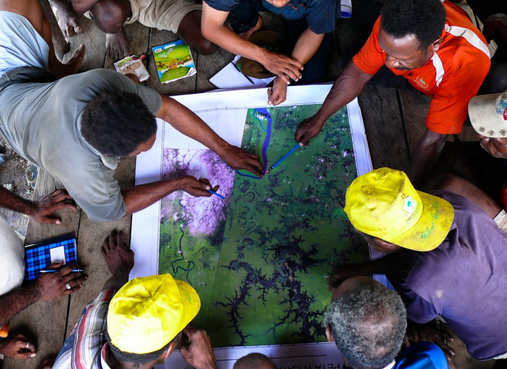
The conventional Geographic Information Systems (GIS) and spatial mapping techniques fail to understand a spatially complex forest area. This is because forest landscapes cannot be easily mapped into a two-dimensional map, which is usually used in spatial planning. In addition, planning maps are the fundamental factors of land grabbing issues. To solve this problem, counter-mapping arises at the local level as a tool to overcome the problem of land grabbing in forest areas in Indonesia. Counter mapping is defined here as part of a broader term under participatory mapping or citizen mapping. However, counter-mapping also faces critiques in terms of different epistemological and socio-economic-political conditions at the local level. This article elaborates the use of GIS and spatial mapping methods within a 'critical' social science approach based on literature review and field experiences. This article also aims to analyze counter-mapping as a ‘tool’ to solve the forest land-use problem, which can contribute to the choice of policy instruments in forest management and conservation in Indonesia.
Appanah, S. (2016). Forest landscape restoration for Asia-Pacific forests. RECOFTC. Retrieved from https://www.recoftc.org/publications/0000150
Ardiansyah, F., Marthen, A. A., & Amalia, N. (2015). Forest and land-use governance in a decentralized Indonesia: A legal and policy review (Vol. 132). CIFOR. https://doi.org/10.17528/cifor/005695
Astuti, R., & McGregor, A. (2017). Indigenous land claims or green grabs? Inclusions and exclusions within forest carbon politics in Indonesia. The Journal of Peasant Studies, 44(2), 445-466. https://doi.org/10.1080/03066150.2016.1197908
Burrough, P. A., McDonnell, R., McDonnell, R. A., & Lloyd, C. D. (2015). Principles of geographical information systems. Oxford university press.
Cockburn, J., Cundill, G., Shackleton, S., & Rouget, M. (2018). Towards place-based research to support social–ecological stewardship. Sustainability, 10(5), 1434. https://doi.org/10.3390/su10051434
De Royer, S., Van Noordwijk, M., & Roshetko, J. M. (2018). Does community-based forest management in Indonesia devolve social justice or social costs?. International Forestry Review, 20(2), 167-180. https://doi.org/10.1505/146554818823767609
McCarthy, J. F. (2007). The Demonstration Effect: Natural Resources, Ethnonationalism and the Aceh Conflict. Singapore Journal of Tropical Geography, 28(3), 314–33. https://doi.org/10.1111/j.1467-9493.2007.00304.x
McGregor, A., Weaver, S., Challies, E., Howson, P., Astuti, R., & Haalboom, B. (2014). Practical critique: Bridging the gap between critical and practice‐oriented REDD+ research communities. Asia Pacific Viewpoint, 55(3), 277-291. https://doi.org/10.1111/apv.12064
Moeliono, M., Thuy, P. T., Bong, I. W., Wong, G. Y., & Brockhaus, M. (2017). Social Forestry-why and for whom? A comparison of policies in Vietnam and Indonesia. Forest and Society, 1(2), 78-97. https://doi.org/10.24259/fs.v1i2.2484
Nietschmann, B. (1995). Defending the Miskito Reefs with maps and GPS: mapping with sail, scuba, and satellite. Cultural survival quarterly, 18(4), 34-37.
Peluso, N. L. (1995). Whose woods are these? Counter‐mapping forest territories in Kalimantan, Indonesia. Antipode, 27(4), 383-406. https://doi.org/10.1111/j.1467-8330.1995.tb00286.x
Peet, R. & Watts, M. (2004). Liberation ecologies: environment, development, social movements. Routledge.
Radjawali, I., Pye, O., & Flitner, M. (2017). Recognition through reconnaissance? Using drones for counter-mapping in Indonesia. The Journal of Peasant Studies, 44(4), 817-833. https://doi.org/10.1080/03066150.2016.1264937
Robbins, P. (2011). Political ecology: A critical introduction. John Wiley & Sons.
Robinson, L.W., Ontiri, E., Alemu, T., & Moiko, S.S. (2017). Transcending landscapes: Working across scales and levels in pastoralist rangeland governance. Environmental Management, 60(2), 185-199. https://doi.org/10.1007/s00267-017-0870-z
Roth, R. (2007). Two-dimensional maps in multi-dimensional worlds: A case of community-based mapping in Northern Thailand. Geoforum, 38(1), 49-59. https://doi.org/10.1016/j.geoforum.2006.05.005
Setyowati, A. B. (2020). Making territory and negotiating citizenship in a climate mitigation initiative in Indonesia. Development and Change, 51(1), 144-166. https://doi.org/10.1111/dech.12541
Van Oosten, C., Gunarso, P., Koesoetjahjo, I., & Wiersum, F. (2014). Governing forest landscape restoration: Cases from Indonesia. Forests, 5(6), 1143-1162. https://doi.org/10.3390/f5061143
World Bank. (2020). Indonesia: Systematic country diagnostic update. The World Bank Group. https://documents1.worldbank.org/curated/en/717421594076964759/pdf/Indonesia-ystematic-Country-Diagnostic-Update.pdf
Copyright (c) 2021 Forest and Society

This work is licensed under a Creative Commons Attribution 4.0 International License.
This is an open access journal which means that all contents is freely available without charge to the user or his/her institution. Users are allowed to read, download, copy, distribute, print, search, or link to the full texts of the articles in this journal without asking prior permission from the publisher or the author. This is in accordance with the BOAI definition of open access.
Submission of an article implies that the work described has not been published previously (except in the form of an abstract or as part of a published lecture or academic thesis), that it is not under consideration for publication elsewhere, that its publication is approved by all authors and tacitly or explicitly by the responsible authorities where the work was carried out, and that, if accepted, will not be published elsewhere in the same form, in English or in any other language, without the written consent of the Publisher. An article based on a section from a completed graduate dissertation may be published in Forest and Society, but only if this is allowed by author's(s') university rules. The Editors reserve the right to edit or otherwise alter all contributions, but authors will receive proofs for approval before publication.
Forest and Society operates a CC-BY 4.0 © license for journal papers. Copyright remains with the author, but Forest and Society is licensed to publish the paper, and the author agrees to make the article available with the CC-BY 4.0 license. Reproduction as another journal article in whole or in part would be plagiarism. Forest and Society reserves all rights except those granted in this copyright notice