
Numerical Modeling and Simulation of Tsunami Hazards in South Seram Island, Indonesia: A Case Study on Kairatu Fault
Article Sidebar
Main Article Content
Abstract
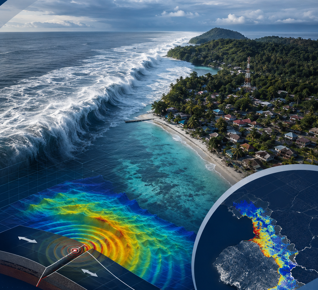
This study aims to analyze the potential for tsunamis caused by tectonic activity along the Kairatu Fault and to evaluate inundation patterns based on numerical modeling results using the COMCOT software. The Kairatu Fault is an active structure in the western part of Seram, with the potential to generate significant earthquakes and trigger tsunamis around Piru Bay and the waters of Ambon. Modeling was conducted using bathymetry data, earthquake source parameters, and seafloor deformation derived from the Okada model. Tsunami simulations were performed to estimate the maximum wave height, wave arrival time, and wave energy distribution along the coastline. Simulation results indicate that the southern coastal areas of Seram and the western coast of Ambon are highly vulnerable to inundation, with wave heights reaching 2–3 m and arrival times around 15–25 min after the earthquake event. Based on these modeling results, it is recommended that the early warning system and coastal spatial planning be strengthened to support tsunami disaster mitigation efforts in the area.
Downloads
Article Details

This work is licensed under a Creative Commons Attribution 4.0 International License.
Accepted 2026-03-31
Published 2026-06-21
References
[1] T. C. Hanks and H. Kanamori, “A moment magnitude scale,” Journal of Geophysical Research, vol. 84, no. B5, pp. 2348–2350, 1979.
[2] K. Harada and F. Imamura, “Study on the effect in reducing tsunami by the coastal permeable structures,” in Proceedings of the 13th Congress of the Asia and Pacific Division of the International Association for Hydraulic Engineering and Research, 2002, pp. 910–915.
[3] M. Nakamura, “Source fault model of the 1771 Yaeyama tsunami, Southern Ryukyu Islands, Japan, inferred from numerical simulation,” Pure and Applied Geophysics, vol. 163, pp. 41–54, 2006.
[4] B. C. Papazachos, E. M. Scordilis, D. G. Panagiotopoulos, C. B. Papazachos, and G. F. Karakaisis, “Global relations between seismic fault parameters and moment magnitude of earthquakes,” Bulletin of the Geological Society of Greece, vol. 36, 2004.
[5] D. P. Sahara, A. D. Nugraha, A. Muhari, A. A. Rusdin, S. Rosalia, A. Priyono, and E. Elly, “Source mechanism and triggered large aftershock of the Mw 6.5 Ambon, Indonesia earthquake,” Tectonophysics, vol. 799, Art. no. 228709, 2021.
[6] D. Sianipar, R. Sipayung, and E. Ulfiana, “Excessive seismicity over a limited source: The August 2019 earthquake swarm near Mt. Salak in West Java, Indonesia,” Journal of Seismology, vol. 24, no. 6, pp. 1189–1204, 2020.
[7] D. L. Wells and K. J. Coppersmith, “New empirical relationships among magnitude, rupture length, rupture width, rupture area, and surface displacement,” Bulletin of the Seismological Society of America, vol. 84, no. 4, pp. 974–1002, 1994.
[8] M. P. Billings, Structural Geology. Englewood Cliffs, NJ, USA: Prentice Hall, 1959.
[9] L. Blaser, F. Krüger, M. Ohrnberger, and F. Scherbaum, “Scaling relations of earthquake source parameter estimates with special focus on subduction environment,” Bulletin of the Seismological Society of America, vol. 100, no. 6, pp. 2914–2926, 2010.
[10] E. Bryant, Tsunami: The Underrated Hazard. Switzerland: Springer, 2014.
[11] L. Hamzah, N. T. Puspito, and F. Imamura, “Tsunami catalog and zones in Indonesia,” Journal of Natural Disaster Science, vol. 22, no. 1, pp. 25–43, 2000.
[12] J. G. Hills and C. L. Mader, “Tsunami produced by the impacts of small asteroids,” Annals of the New York Academy of Sciences, vol. 822, pp. 381–394, 1997.
[13] F. Imamura, A. C. Yalçiner, and G. Ozyurt, Tsunami Modelling Manual. 2006.
[14] J. Nugraha, M. Mawaleda, M. Farida, Muzli, S. Rohadi, M. Sadly, and D. K., “Pulau Seram dan sekitarnya menyimpan potensi gempabumi tektonik dalam skala besar,” 2017.
[15] H. Kanamori, “Mechanism of tsunami earthquakes,” Physics of the Earth and Planetary Interiors, vol. 6, no. 5, pp. 346–359, 1972.
[16] L. Kurniawan, “Perencanaan kedaruratan dalam menghadapi bencana tsunami,” Alami, vol. 10, no. 2, pp. 53–57, 2005.
[17] F. A. T. Laksono, M. R. Aditama, R. Setijadi, and G. Ramadhan, “Run-up height and flow depth simulation of the 2006 South Java tsunami using COMCOT on Widarapayung Beach,” IOP Conference Series: Materials Science and Engineering, Art. no. 012047, 2020.
[18] H. Latief, “Tsunami Aceh 2004,” 2005. [Online]. Available: http://www.emsccsem.org/Doc/SUMATRA_261204/Presentasi-tsunami-Aceh-hamzah.pdf. [Accessed: Dec. 20, 2022].
[19] Madrinovella, S. Widiyantoro, and I. Meilano, “Relokasi hiposenter gempa Padang 30 September 2009 menggunakan metode double difference,” Jurnal Teknik Mesin, vol. XVII, no. 1, 2011.
[20] T. W. Nurhalita, “Studi tingkat bahaya tsunami terhadap bandar udara dan pelabuhan laut di Nusa Tenggara Timur,” Undergraduate thesis, Program Studi Geofisika, Sekolah Tinggi Meteorologi Klimatologi dan Geofisika, Tangerang Selatan, Indonesia, 2017.
[21] Pusat Studi Gempa Nasional, Peta Sumber dan Bahaya Gempa Indonesia Tahun 2017. Bandung, Indonesia: Pusat Penelitian dan Pengembangan Perumahan dan Permukiman, Kementerian Pekerjaan Umum dan Perumahan Rakyat, 2017.
[22] P. L.-F. Liu, Y.-S. Cho, S. B. Yoon, and S. N. Seo, “Numerical simulations of the 1960 Chilean tsunami propagation and inundation at Hilo, Hawaii,” in Recent Development in Tsunami Research. Dordrecht, The Netherlands: Kluwer Academic Publishers, 1994, pp. 99–115.
[23] D. Ruswandi, Indeks Risiko Bencana Indonesia Tahun 2013. Jakarta, Indonesia: Direktorat Pengurangan Risiko Bencana, Deputi Bidang Pencegahan dan Kesiapsiagaan, Badan Nasional Penanggulangan Bencana, 2014.
[24] G. Shanmugam, Slides, Slumps, Debris Flows, and Turbidity Currents. Texas, USA: Elsevier, 2013.
[25] P. M. Shearer, Introduction to Seismology. New York, NY, USA: Cambridge University Press, 2009.
[26] X. Wang and W. L. Power, COMCOT: A Tsunami Generation, Propagation and Run-Up Model. USA: GNS Science, 2011.