
Mapping the Distribution of Sediment Types Using Core Sampling Methods on the Coast of Prancak Village, Bangkalan Regency, Indonesia
Article Sidebar
Main Article Content
Abstract
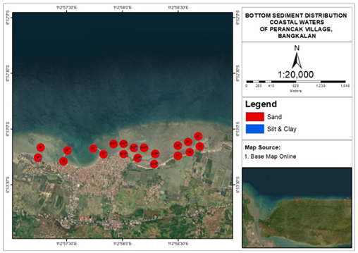
Prancak Village is a coastal village located in Sepulu Subdistrict, Bangkalan Regency, which has an important ecosystem in the form of coral reefs and seagrass beds. This study aims to map the distribution of bottom sediments and determine the influence of hydrodynamic conditions on sediment distribution. Data collection was conducted at 20 stations using a core sampler, and sediment samples were analyzed for granulometry in the laboratory. Supporting parameters such as currents, waves, tides, and bathymetry were also recorded. The results of this study show that bottom sediments in the coastal area of Prancak Village are dominated by sand with a sand content of 94.914-99.598% and silt and clay content ranging from 0.323-5.086%. The results of sediment classification showed that fine sand dominated at some points, while coarse mud dominated at other locations. The dominance of sandy sediments in the coastal area of Prancak Village creates substrate conditions that support seagrass growth and the sustainability of the coral reef ecosystem. This study provides information on the distribution of bottom sediments as a basis for coastal management and development planning, as well as erosion and sedimentation mitigation in the coastal area of Prancak Village, Bangkalan Regency.
Downloads
Article Details

This work is licensed under a Creative Commons Attribution 4.0 International License.
Accepted 2025-12-30
Published 2026-02-05